Creating a subdivision map in the US is an essential process in land development. This article explores key concepts and steps involved in making a successful subdivision map. It will cover everything from the importance of these maps to the tools and techniques used for effective design. Readers will find insights on navigating legal requirements, overcoming challenges, and enhancing community development through quality mapping.
- Understand local zoning laws.
- Gather property data and details.
- Use mapping software or tools.
- Create a clear layout for subdivisions.
- Review the map for accuracy before submission.

Understanding the Basics of Subdivision Map Creation
What is a Subdivision Map?
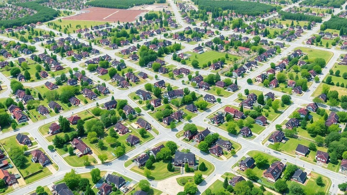
A subdivision map is a detailed drawing that shows how a piece of land is divided into smaller lots. It outlines the boundaries of each lot, streets, and other important features. This map is essential for anyone looking to develop land. It helps visualize the layout and guides the planning process.
Importance of Subdivision Maps in Land Development
Subdivision maps play a crucial role in land development. They are not just drawings; they are legal documents that help in several ways:
- Zoning Compliance: They ensure that the land use meets local zoning laws, which are essential for understanding land zoning.
- Infrastructure Planning: They show where roads, utilities, and other infrastructure will go.
- Investment Decisions: Investors use these maps to understand the potential of the land.
Key Elements of a Subdivision Map
A subdivision map contains several key elements that make it effective. Here’s a breakdown of what to look for:
| Element | Description |
|---|---|
| Lot Boundaries | Lines that define each individual lot. |
| Streets | Roads that provide access to the lots. |
| Easements | Areas where others have the right to use the land. |
| Utilities | Locations for water, gas, electricity, and sewer lines. |
| Landmarks | Notable features like parks or lakes nearby. |
Understanding these elements helps investors and developers make informed decisions. Whether they are looking to buy, sell, or develop land, knowing how to create a subdivision map in the US is essential for success. For more guidance, check out how to start land development.

Steps to Create a Subdivision Map in the US
Initial Planning for Subdivision Map Creation
Creating a subdivision map in the US starts with initial planning. This step involves defining the project’s goals and understanding the local market. Investors should gather information about the land, including its size, shape, and current zoning laws. A well-thought-out plan serves as the foundation for the entire project.
The following should be considered during initial planning:
- Location Analysis: Assess the area to determine its potential for development.
- Market Research: Understand what buyers are looking for in a subdivision.
- Budgeting: Estimate costs for land development, including utilities and infrastructure.
Legal Requirements for Subdivision Mapping
Legal requirements play a crucial role in creating a subdivision map. Each state has specific laws governing land development. Investors must familiarize themselves with these rules to avoid complications down the line.
Key legal steps include:
- Zoning Approval: Check if the land is zoned for residential or commercial use.
- Permits: Obtain necessary permits before starting the mapping process.
- Environmental Assessments: Conduct assessments to ensure compliance with environmental laws.
Common Regulations in US Subdivision Mapping
Understanding common regulations is vital for successful subdivision mapping. Regulations can vary widely by state and local jurisdiction. Here is a table summarizing some of the most common regulations:
| Regulation Type | Description |
|---|---|
| Subdivision Ordinances | Local laws that dictate how land can be divided. |
| Building Codes | Standards for construction to ensure safety. |
| Setback Requirements | Minimum distances buildings must be from property lines. |
| Utility Regulations | Guidelines for connecting to water, sewer, and electricity. |
Navigating these regulations can be challenging. Therefore, seeking advice from local planning departments or hiring a professional can be beneficial. For insights on the best states for land development, refer to this resource.

Tools for Creating a Subdivision Map
Overview of Online Subdivision Map Creators
Creating a subdivision map is a critical step for developers and investors looking to break new ground in real estate. Online subdivision map creators are user-friendly tools that allow users to design and visualize land layouts. These platforms help in crafting detailed maps that showcase property lines, zoning areas, and infrastructure. With just a few clicks, one can transform ideas into a practical layout. For a list of the best tools available, check this guide.
Advantages of Using Subdivision Mapping Tools
Using subdivision mapping tools offers several key benefits:
- Time Efficiency: These tools can save hours of manual drafting.
- Cost-Effective: Many online options are free or low-cost, making them accessible.
- Accuracy: They provide precise measurements and placements, reducing errors.
- Collaboration: Users can easily share maps with team members or stakeholders for feedback.
These advantages make it easier for developers to focus on the bigger picture while ensuring their maps are accurate and professional.
Popular Software for Subdivision Layout Planning
Several software options stand out in the market for subdivision layout planning. Below is a table summarizing some of the most popular choices:
| Software Name | Key Features | Pricing Model |
|---|---|---|
| AutoCAD | Advanced drawing tools, 3D modeling | Subscription-based |
| SketchUp | Simple interface, 3D visualization | Free and paid versions |
| GIS Mapping Tools | Geographic data integration | Varies by provider |
| Land F/X | Landscape design features | Subscription-based |
These tools are designed to help users navigate the complexities of land development, making the process smoother and more efficient.

Techniques for Effective Subdivision Design
Best Practices in Subdivision Design Techniques
When designing subdivisions, it is crucial to follow certain best practices. These practices help create functional and appealing spaces for communities. Here are some key points to consider:
- Understand Local Zoning Laws: Knowing the rules of the land can save time and money. Each area has different regulations that must be followed.
- Incorporate Green Spaces: Parks and gardens can enhance the quality of life for residents. They provide places for recreation and relaxation.
- Plan for Accessibility: Ensure that roads and pathways are easy to navigate. This includes considering the needs of pedestrians and cyclists.
- Utilize Natural Features: Working with the land’s natural characteristics can add to the beauty of the subdivision. This might involve preserving trees or using hills in the layout.
- Engage with the Community: Getting feedback from potential residents can lead to better designs. It helps to understand what people really want in their neighborhoods.
Common Mistakes to Avoid in Subdivision Planning
While planning subdivisions, it is easy to make mistakes. Here are some common pitfalls to watch out for:
- Neglecting Infrastructure: Failing to plan for roads, water, and sewage can lead to major issues later on. Infrastructure is the backbone of any subdivision.
- Ignoring Environmental Impact: Not considering how development affects the environment can lead to problems. This includes issues like flooding and loss of wildlife habitats.
- Overcrowding: Trying to fit too many homes into a small area can create a cramped feeling. It’s important to balance density with livability.
- Lack of Future Planning: Focusing only on current needs without thinking about future growth can limit a subdivision’s success. Anticipating changes can help maintain its appeal.
Enhancing Usability in Subdivision Layouts
Creating a usable subdivision layout is key to attracting residents. Here are some tips for enhancing usability:
- Create Clear Pathways: Well-marked paths and roads help people navigate easily. This includes signs and lighting for safety.
- Design with Flexibility: Consider spaces that can serve multiple purposes. For instance, a community center can host events and provide recreational opportunities.
- Incorporate Amenities: Adding features like playgrounds, shopping areas, and fitness centers can make a subdivision more appealing. These amenities draw people in and foster community ties.
- Focus on Aesthetics: A visually pleasing environment can elevate the overall experience. This may involve landscaping, attractive architecture, and thoughtful design elements.
| Tip | Description |
|---|---|
| Clear Pathways | Easy navigation for residents and visitors. |
| Flexible Design | Spaces that serve multiple functions. |
| Amenities | Features that enhance lifestyle and community. |
| Aesthetic Focus | Visually appealing designs attract more residents. |

Benefits of a Well-Designed Subdivision Map
Impact on Property Value and Marketability
A well-designed subdivision map plays a crucial role in determining property values. When potential buyers look at a property, they often consider the layout and accessibility of the area. A clear and organized map can highlight key features such as parks, schools, and shopping centers. These amenities can significantly increase the marketability of the properties within the subdivision.
For instance, a subdivision that includes walking paths and communal spaces tends to attract families and young professionals. This increased interest can lead to higher property values, making it a win-win for both developers and investors.
Facilitating Community Development through Effective Mapping
Effective mapping does more than just outline lots; it also fosters community development. A thoughtfully crafted subdivision map can guide the planning of essential services and infrastructure. This includes roads, utilities, and public spaces, which are vital for a thriving community.
For example, a subdivision map that includes designated areas for community gardens or playgrounds can promote social interaction among residents. These features not only enhance the quality of life but also encourage a sense of belonging, which is crucial in today’s society.

Challenges in Subdivision Map Creation
Navigating Zoning Laws and Regulations
When creating a subdivision map in the US, zoning laws can present significant hurdles. Each locality has its own regulations that dictate land use, building heights, and lot sizes. These laws can vary widely from one area to another, making it crucial for developers to understand the specific rules governing their project site.
For example, a developer might find that a piece of land zoned for residential use cannot be transformed into commercial space without a lengthy approval process. This can delay projects and increase costs. Therefore, it is essential for investors to conduct thorough research on zoning laws before embarking on the subdivision mapping journey.
Addressing Environmental Concerns in Mapping
Environmental considerations are another critical aspect of subdivision map creation. Developers must assess how their projects will impact local ecosystems. This includes evaluating the presence of wetlands, endangered species, and other natural resources.
Failure to address these concerns can lead to significant setbacks, including fines or project cancellations. To illustrate, a developer aiming to build homes near a river may need to conduct an environmental impact study to ensure that the project does not harm aquatic life. This step is vital to secure necessary permits and maintain community support.
Strategies to Overcome Subdivision Mapping Challenges
To effectively tackle the challenges of subdivision mapping, developers can adopt several strategies:
| Strategy | Description |
|---|---|
| Engage Local Experts | Collaborate with land use planners and environmental consultants to navigate regulations effectively. |
| Conduct Thorough Research | Investigate zoning laws, environmental regulations, and community needs before starting the mapping process. |
| Utilize Technology | Leverage mapping software and GIS tools to visualize land use and plan layouts more efficiently. |
| Communicate with Stakeholders | Foster relationships with local authorities and community members to gain insights and support. |
By implementing these strategies, developers can streamline the subdivision mapping process and mitigate potential roadblocks.

Case Studies of Successful Subdivision Maps
Examples of Effective US Subdivision Mapping
In various parts of the United States, successful subdivision maps have transformed landscapes and communities. For instance, the Lakewood Ranch in Florida stands out as a prime example. This community was carefully planned to include homes, parks, and commercial areas, all connected by walking paths. The subdivision map clearly outlines each section, making it easy for residents to navigate their surroundings.
Another notable example is the Boulder Valley in Colorado. The subdivision map here integrates natural features like rivers and hills, promoting a harmonious blend of nature and urban living. This careful design not only attracts residents but also supports local wildlife.
Lessons Learned from Successful Subdivision Projects
Successful subdivision projects offer vital lessons. Here are some key takeaways:
- Community Involvement: Engaging residents early in the planning process can lead to better outcomes.
- Flexibility: Maps should allow for future changes, accommodating growth and new needs.
- Sustainability: Incorporating green spaces and eco-friendly designs can enhance property value and community satisfaction.
Analyzing the Impact of Good Subdivision Maps
Good subdivision maps have a significant impact on communities. They can influence property values, enhance resident satisfaction, and promote a sense of belonging. A well-designed map serves as a guide, helping residents feel at home.
| Impact Area | Description |
|---|---|
| Property Values | Well-planned subdivisions often see higher property values. |
| Community Engagement | Clear maps foster a sense of belonging and interaction. |
| Environmental Benefits | Incorporating green spaces improves air quality and aesthetics. |

Future Trends in Subdivision Mapping
The Role of Technology in Subdivision Map Creation
Technology has become a game-changer in the field of subdivision mapping. Tools like Geographic Information Systems (GIS) and 3D modeling software allow planners to create detailed maps with precision. These technologies help visualize land use, zoning, and infrastructure. By using satellite imagery and drones, developers can gather data faster and more accurately than ever before.
For instance, a developer might use GIS to determine the best layout for a new community. This data-driven approach helps them make informed decisions, reducing the risk of costly mistakes.
Predictions for the Future of US Subdivision Mapping
Looking ahead, several trends are likely to shape the future of subdivision mapping in the U.S. Here are a few predictions:
- Increased Use of Artificial Intelligence (AI): AI can analyze vast amounts of data to identify trends and patterns in land use.
- Sustainable Practices: There will be a stronger focus on environmentally friendly designs, such as green spaces and energy-efficient buildings.
- Smart City Integration: Subdivision maps will increasingly incorporate smart technology, such as sensors for traffic and utilities.
| Trend | Impact |
|---|---|
| Increased Use of AI | Enhances decision-making and efficiency |
| Sustainable Practices | Promotes eco-friendly development |
| Smart City Integration | Improves urban living and infrastructure |
Innovations Shaping Subdivision Design and Planning
Several innovations are currently influencing subdivision design and planning. These include:
- Virtual Reality (VR): Developers can use VR to create immersive experiences for potential buyers, allowing them to walk through a subdivision before it’s built.
- Modular Construction: This method allows for faster building times and reduced costs, making it easier to respond to market demands.
- Community Engagement Tools: Online platforms enable residents to provide feedback on proposed developments, fostering a sense of community involvement.
These advancements not only streamline the mapping process but also make it easier for investors to visualize and understand the potential of a subdivision.

Resources for Learning How to Create Subdivision Map in US
Recommended Books and Guides on Subdivision Mapping
For those interested in how to create subdivision map in US, several books and guides can provide valuable insights. Below is a list of recommended resources:
| Title | Author | Description |
|---|---|---|
| Subdivision Design and Development | John Smith | This book covers the basics of subdivision design, including zoning laws and land use. |
| Mapping Your Future: A Guide to Subdivision Planning | Sarah Johnson | A practical guide that walks readers through the steps of creating a subdivision map, complete with examples and case studies. |
| The Complete Guide to Land Development | Michael Brown | This comprehensive resource includes chapters on mapping, planning, and executing land development projects. |
These books serve as a solid foundation for understanding the intricacies of subdivision mapping.
Online Courses for Subdivision Map Creation
In addition to books, many online platforms offer courses focused on subdivision map creation. Here are some noteworthy options:
- Coursera: Offers a course titled “Land Use Planning and Development,” which includes modules on subdivision mapping.
- Udemy: Features classes like “Introduction to Subdivision Planning,” where learners can gain practical skills.
- LinkedIn Learning: Provides several courses related to real estate development, including mapping techniques.
These courses are designed to equip individuals with the necessary skills to tackle subdivision mapping effectively.
Networking Opportunities for Land Development Professionals
Networking plays a crucial role in the land development sector. Here are some avenues where professionals can connect:
- Industry Conferences: Events such as the National Association of Home Builders (NAHB) conference provide opportunities to meet experts and share knowledge.
- Local Meetups: Many cities host regular meetups for land developers, which can be a great way to exchange ideas and experiences.
- Online Forums: Platforms like LinkedIn and dedicated real estate forums allow for ongoing discussions and connections with peers.
Building a network can significantly enhance one’s understanding and execution of subdivision mapping.
In the End…
In summary, the creation of a subdivision map is a pivotal process in land development that demands careful consideration of zoning laws, legal requirements, and the community’s needs. By understanding the key elements and employing effective tools and techniques, developers can navigate the complexities of mapping with confidence. Moreover, acknowledging the challenges and leveraging innovative technologies will empower them to create functional and aesthetically pleasing subdivisions that enhance property values and foster community development. As the landscape of land development continues to evolve, staying informed about the latest trends and resources is essential for success.
For further insights and articles on land development, readers are encouraged to explore more at Land Development Hub.
Eduardo Bugallo, PhD
No responses yet